Bangladesh all District MAP


Khulna
Bagerhat • Chuadanga • Jessore • Jhinaidah • Khulna • Kushtia • Magura • Meherpur • Narail • Satkhira


Barisal Division
Barisal is one of the eight administrative divisions of Bangladesh. Located in the south-central part of the country, it has an area of 13,644.85 km2 (5,268.31 sq mi), and a population of 8,325,666 at the 2011 Census. It is bounded by Dhaka Division on the north, the Bay of Bengal on the south, Chittagong Division on the east and Khulna Division on the west. The administrative capital, Barisal city, lies in the Ganges (Padma) River delta on an offshoot of the Arial Khan River (Kirtonkhola). Barisal division is criss-crossed by numerous rivers that earned it the nickname ‘Dhan-Nodi-Khal, Ei tine Borishal’ (rice, river and canal built Barisal).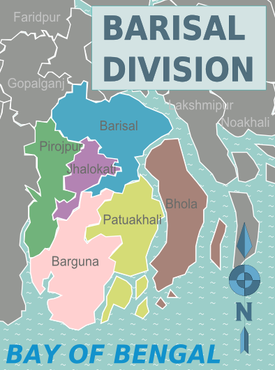
Early Middle Ages
In early times the Barisal region was composed of an amalgamation of marshlands formed by the merging of islands brought into existence and built up by alluvial soils washed down the great channels of the combined Brahmaputra-Ganges-Meghna river systems.
In the early 13th century, when Muhammad bin Tughluq completely conquered eastern Bengal, Hindu chieftains from northwest Bengal were dislodged from power and they dispersed over Barisal region and founded the kingdom of Bakla.[citation needed]
During the Mughal conquest in Bengal, Hindu society was concentrated to northern and western Barisal (known as Bakarganj). Barisal’s southern portion was still covered by forests and laced with lagoons. The northwest was also the only part of Bakarganj where the Hindu population exceeded Muslims in early British censuses.[citation needed]
Mughal period
Barisal saw a second wave of immigration in the late 17th and early 18th centuries . This time, it was Muslim pioneers who assumed the leading role. Establishing Dhaka as the provincial Mughal capital of the region, in the early 17th century the Barisal region (known as Sarkar Bakla to Mughals) was more accessible to businessmen and developers than at any previous time. However, piracy in this region along the coasts and rivers of southeastern Bengal by Arakanese and renegade Portuguese seamen inhibited any sustained attempts by Mughal governors to push into the Barisal forests.
After 1666, when Mughal naval forces cleared the Meghna estuary of such external threats, the Barisal interior lay ripe for colonization. Land developers acquired grants of plots of land, taluq (তালুক), from provincial authorities. Abundant and easily obtainable by purchase from the late 17th century these grants tended to be regarded by their possessors taluqdar (তালুকদার). As taluqdars brought their taluqs into agricultural production, these men passed up the land revenue through a class of non-cultivating intermediaries, or zamindar (জমিদার). Zamindars typically resided in the provincial capital, where they had ready access to the chief provincial revenue officer, or dewan (দেওয়ান).
In a second pattern of land development, Muslim pirs or Qazi went directly into uncultivated regions, organized the local population for clearing the jungles, and only later, after having established themselves as local men of influence, entered into relations with the Mughal authorities. Relationships between the religious Muslim pirs and Mughal authorities was not always harmonious, since a pir’s natural ties of authority and patronage generally lay with the masses of peasants beneath him and not with the governors and bureaucrats. For example, in remote Jhalakati Thana in the eastern Bakarganj, an 18th-century pir named Saiyid Faqir wielded enormous influence with the cultivators of the all-Muslim village of Saiyidpur, named after the pir. But a difficulty arose, noted a 1906 village survey, because “the people of this part looked upon the Fakir as their guide and did not pay rent to the Nawab.” In this situation, one Lala Chet Singh, a captain in the employ of the governor, “succeeded in persuading the Fakir to leave the country.
Barisal was once known as the “Granary of Bengal” for its rich production. It is still an important rice producing area of the country. Since the Middle Ages, Barisal has acted as a trans-shipment center for hides, rice, dried beans, dried peas, lentils, chickpeas, and other pulses for Bengal. Bakery, textile, and pharmaceutical products are the output of a few industrial installations. There is a medical college (Sher-e Bangla Medical College) affiliated with the National University. The most famous education institution of Barisal Division is B. M. College (established in 1889). Barisal is also a river port once connecting Calcutta-Barisal-Dhaka and many other routes. Today Barisal River port is the most important hub of steamer and motor launch service of the Southern Bangladesh.
Kuakata beach is the main tourist spot in the division. It is one of the two sea beaches in South Asia where both sunrise and sunset at sea can be seen.
Durga Sagor is another beautiful Dighi where a number of migratory birds arrive every winter. There are 42 upazilas in total in Barisal division: most recent upazilas are Rangabali in Patuakhali and Taltoli in Barguna.
Numerous rivers and canals force the inhabitants to use boats as the main medium of transportation. The main rivers are the Arial Khan, Bishkhali, Burishwar, Tentulia, Paira, Haringhata, Baleshwar, Kirtankhola, Katcha, and Agunmukha. It is linked by steamer with Dhaka (73 miles [117 km] to the north) and with Chittagong to the southeast. Road communication has improved significantly over last decades with the building of many bridges. The Barisal airport has regular service to Dhaka.
Barisal division has one of the highest literacy rates of the country, just behind Dhaka division. One of the country’s oldest educational institutions, Brojomohun College was established in 1889. The division contains Sher e Bangla Medical College and one science and technological university. Recently the government has passed a bill approving the building of the new Barisal University.
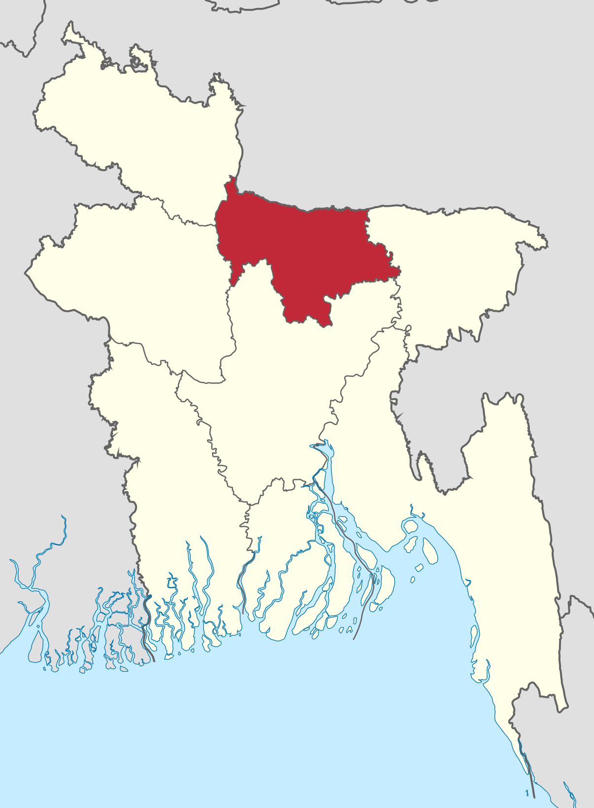
Mymensingh Division
Division Maimansinghময়মনসিংহ বিভাগ,

Mymensingh Division (Bengali: ময়মনসিংহ বিভাগ) is one of the eight administrative divisions of Bangladesh. It has an area of 10,485 km² and a population of 11,370,000 as of the 2011 census. It was created in 2015 from districts previously comprising the northern part of Dhaka Division. Its headquarters are in Mymensingh city in Mymensingh District.
The Greater Mymensingh region (Mymensingh District along with six other neighbouring districts) was created as a Mymensingh district by the British Indian government in 1787.
Later, it was reorganized in two phases into six districts –
- Mymensingh,
- Kishoreganj,
- Netrakona,
- Tangail,
- Jamalpur,
- Sherpur.
On 12 January 2015 prime minister Sheikh Hasina declared the establishment of a new Mymensingh Division. The intention was that this would carve six districts (those comprising the original Mymensingh district of 1787) out of the Dhaka Division. However, while four of the districts were eager about the establishment of new division, people of Tangail and Kishorgonj Districts wanted to remain part of Dhaka Division.On 14 September 2015 Mymensingh was officially announced as a division consisting four districts.


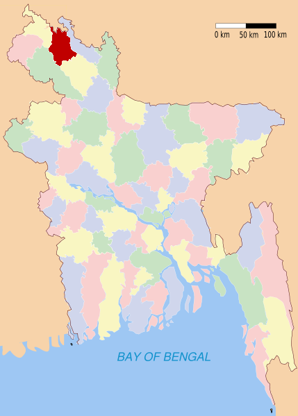
Bagerhat
Bagerhat district has a total area of 3959.11 square kilometres. It is bounded by Gopalganj District and Narail District on the north, The Bay of Bengal on the south, Gopalganj District, Pirojpur District and Barguna District on the east and Khulna District on the west. Main rivers of the district are Panguchi, Daratana, Madhumati River, Pasur River, Haringhata, Mongla River, Baleshwar, Bangra and Goshairkhali.

Bagerhat is divided into 9 upazilas, 77 union parishads, 1031 villages, 687 mouzas, 3 municipalities, 27 wards and 56 mahallas. The upazilas are:
Points of interest
|
|

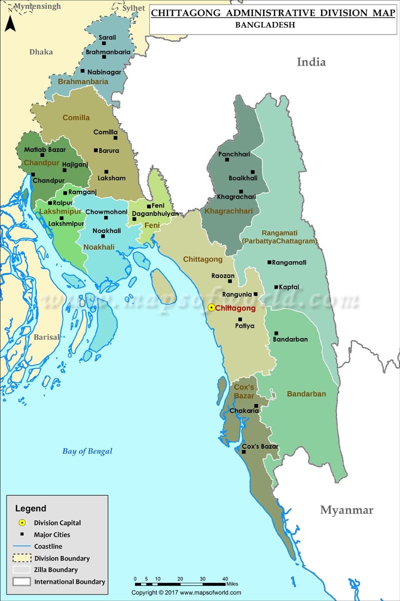
Bandarban


Barguna

Barisal


Cox’s Bazar

Dhaka

Dinajpur


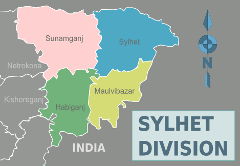
Habiganj


Jamalpur

Jessore


Kurigram

Kushtia

Lakshmipur


Lalmonirhat

Madaripur

Magura

Manikganj

Meherpur

Moulvibazar

Munshiganj

Mymensingh

Naogaon


Narail

Narayanganj


Narsingdi

Natore

Netrokona


Nilphamari


Noakhali
নোয়াখালী বাংলাদেশের একমাত্র জেলা যার নিজ নামে কোন শহর নেই। নোয়াখালী জেলা শহর মাইজদী নামে পরিচিত। ১৯৪৮ সালে যখন উপজেলা সদর দফতর মেঘনা গর্ভে বিলীন হয়ে যায়, তখন তা ৮ কিলোমিটার উত্তরে সরিয়ে ১৯৫০ সালে জেলার সদর দপ্তর অস্থায়ীভাবে মাইজদীতে স্থানান্তর করা হয়। বৃটিশদের পরিকলপনায় নতুন করে এ শহরের পত্তন হয়। নোয়াখালী শহর যখন ভেঙ্গে যাচ্ছিলো তখন মাইজদী মৌজায় ধান ক্ষেত আর খোলা প্রান্তরে পুরাতন শহরের ভাঙ্গা অফিস আদালত গুলো এখানে এনে স্থাপন করা হয় এবং ১৯৫৩ সালে শহরের পুরনো এলাকা কালিতারা, সোনাপুর ও মাইজদীসহ কাদির হানিফ ইউনিয়নের কয়েকটি মৌজা নিয়ে গেজেট বিজ্ঞপ্তিতে নোয়াখালী পৌর এলাকা ঘোষণা করা হয়। শহরের প্রাণ কেন্দ্রে প্রায় ষোলো একর জুড়ে কাটা হয় এক বিশাল দীঘি। লোক মুখে প্রচলিত হয় বড় দীঘি নামে। সে দীঘির চতুর্দিকে চক্রাকারে বানানো হয় ইট সুরকীর রাস্তা। সে রাস্তাকে ঘিরে বাংলো প্যাটার্ণে তৈরী হয় সরকারী সব দপ্তর। এই দীঘিটি ব্যবহৃত হতো মূলত: শহরে জলাধার হিসে্বে, দীঘিতে পাম্প লাগিয়ে বিভিন্ন সরকারি অফিস- আদালত এবং আবাসিক এলাকায় পানি-সরবরাহ করা হতো। মাইজদী শহর স্থানান্তর করলেও সুদীর্ঘ প্রায় একযুগ পর্যন্ত মাইজদীকে নোয়াখালী জেলার সদরদপ্তর হিসেবে সরকারিভাবে স্বীকৃতি দেওয়ার বিষয়টি বিতর্কিত অবস্থায় ছিলো। অবশেষে ১৯৬২ সালে মাইজদীকে নোয়াখালী জেলার স্থায়ী সদর দপ্তর হিসাবে সরকারিভাবে স্বীকৃতি দেয়া হয়।
- চৌমুহনী নোয়াখালীর আরেকটি ব্যস্ত শহর ও বাণিজ্য কেন্দ্র, যা একসময়ে মুদ্রণ ও প্রকাশনা ব্যবসার জন্য বিখ্যাত ছিল।
- নিঝুম দ্বীপ
- শহীদ ভুলু স্টেডিয়াম
- বজরা শাহী মসজিদ
- গান্ধি আশ্রম
- ম্যানগ্রোভ বনাঞ্চল, চর জব্বর
- নোয়াখালী জেলা জামে মসজিদ, মাইজদী
- নোয়াখালী কেন্দ্রীয় শহীদ মিনার, মাইজদী
- মাইজদী কোর্ট বিল্ডিং দীঘি, মাইজদী
- বীরশ্রেষ্ঠ শহীদ মোহাম্মদ রুহুল আমিন গ্রন্থাগার ও স্মৃতি জাদুঘর, সোনাইমুড়ী
- মহাত্মা গান্ধী জাদুঘর
- মুছাপুর ক্লোজার, কোম্পানিগঞ্জ


Pabna

Panchagarh


Patuakhali

Pirojpur


Rajbari

Rajshahi

Rangamati

Rangpur


Satkhira


Shariatpur


Sherpur
Sirajganj

Sunamganj

Sylhet

Tangail

Thakurgaon

Map of Kishoreganj District
Bogra

Map of Bagerhat District


This district was established as Tripura district in 1790. It was renamed Comilla in 1960. Comilla is a district of Bangladesh located about 100 kilometers south-east of Dhaka. Comilla district police has a rich history in terms of serving the people. It has been operational for a long time and with time has gained quite a legacy. Munshi Kabiruddin, the suprintendent of Comilla district police in 1971, along with his RI Abdul Halim and his son Mukul and Bakul are recognized to be the first martyrs of the war for independence. It is one of the most densely populated districts in the country and in order to cover all the regions in the district, the district police has divided itself into 16 police stations. The police stations are Kotowali model, Sadar dakkhin, Daudkandi model, Chandina, Muradnagar, Choddogram, Debiddar, Burichang, Laksham, Nangolkot, Borura, Bipara, Homna, Titas, Monohorganj and Meghna. Five of these stations are in regions that are located near the Bangladesh-India border. The eastern wing of Bangladesh highway police is located in Comilla, which has the responsibility of protecting vehicles and travelers from highway robbery. They also monitor the highway for any speeding vehicles that might pose mortal danger for unsuspecting travelers.


মন্তব্যসমূহ
একটি মন্তব্য পোস্ট করুন